The season of tornadoes, hailstorms, and other weather events is not pausing the country. Only a few weeks after the Nicole warnings, the Storm Prediction Center issued a new warning about new weather events.
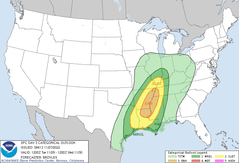
These damaging weather events may take place in the lower Mississippi River Valley, according to the early forecasting warning of the Storm Prediction Center.
Large storms are possible, with the threat of severe weather, including tornadoes and large hail. The details regarding at-risk areas will become clearer as Tuesday nears and smaller-scale trends become more obvious.
The prediction center noted Sunday morning that there was a potential for severe weather to become “categorical” as Tuesday’s forecast approaches.
This means the severe storm threat is considered to be Level 4 or 5 out of 5, with the risk increasing during this time.
Storms this week are expected to be stronger than usual and could potentially leave significant damage in their wake. It’s advised to everyone to stay up-to-date on the latest forecast as it develops over the next day or so.
If you live in the lower Mississippi River Valley, brace for a tornado or wind storm after dark on Tuesday. These weather events are particularly dangerous, so preparing in advance will be beneficial.
One factor that can influence the fatality rate of a tornado is the time of day when it occurs.
Nocturnal tornadoes are more dangerous than their daytime counterparts because many people are asleep during their occurrence. This makes them an especially vicious storm for everyone connected to the storm, as those sleeping don’t have time to seek shelter.
Regardless of whether the greater tornado threat for this particular event is during the day or at night, there is still the potential for a few rotating storms to come through.

For Tuesday night, the areas most at risk for a nocturnal storm are southern Illinois all the way down to Louisiana.
Another challenge with night tornadoes, especially in the fall and winter, is that storms typically move very quickly. This means that you must make decisions quickly and be ready to take shelter based on information contained in thunderstorms or tornado warnings.
The Storm Prediction Center noted that the potential for wind and flooding rises with each successive round of thunderstorms.
Though heavier storms are less likely to result in widespread flooding, isolated locations could see up to 4 inches of rainfall all over the region.
Tornadoes are a common occurrence in the US, with these devastating events primarily taking place during warmer months. With climate change, there may be a trend towards increased tornadoes in the spring as colder air clashes with hot air.
In other words, tornado season is changing and might end up happening later on in the year instead of early springtime.
Therefore, prepare for severe weather with a strategy. Make sure you have enough batteries and flashlights, as well as fully charged cell phones.
You can also prepare other items that could be required in case there are power outages or natural disasters.


